Alert! Alert! You’re five feet away from a COVID-19 zone.
If you’ve ever worried about visiting a COVID-19 hotspot unknowingly, Google Maps has you covered.
Only yesterday, Google added a tool that helps users identify high-risk areas wherever they are.
This way, you can tell where is or isn’t safe to visit by using Google Maps.

Google has a name for this new addition to its map. Call it the “COVID-19 layer”.
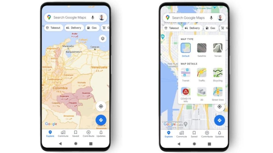
To see the COVID-19 layer, click on the info layer at the maps’ top right hand. After, click the Covid-19 info layer to get details about an area.
Just in case you can’t see the Covid-19 layer in your maps, don’t fret.
The feature isn’t widely available yet, as it will be released gradually.
Suppose you’re among the lucky first, on the other hand, good for you.
You should see the new cases per 100,00 people in any area you select.
The cases shown will be those within the last seven days.
Features in the tool

Interestingly, the new tool has some features that help its efficiency.
For example, the tool includes colour-coding to help understand the weight of cases in the area.
Grey signifies less than 1 case. Yellow is for cases between 1 to 10.
Orange is for cases within the range of 10 to 20. Dark orange is for 20 to 30 cases.
Red symbolizes 30 to 40 cases. And finally, dark red is for cases above 40.
Also, some tags tell if the cases in an area are increasing or decreasing.
There are also trending case data for the 220 countries supported by Google maps.
The data also covers states, provinces, counties, and cities that Google covers.
In interpretation, places that aren’t covered by Google will be left grey.
How Google gathers the data
If you’re as curious as we were about how Google gathered the data to identify COVID-19 hotspots, it’s simple.
Google employed numerous certified sources to gather information.
For the most part, these sources include John Hopkins, Wikipedia, and the New York Times.
All of which take data from health organisations where COVID-19 is concerned.
ALSO READ: How to Use Google Maps Offline
The health organisations are government health ministries, health agencies, and hospitals.
Of course, the list includes the World Health Organisation (WHO).
According to Google, all of these sources head information on COVID-19.
Now, the information will be offered to Google maps.
We expect the new tool to begin appearing on android and iOS devices this week.
If you ask us, we think this new addition to Google maps is much needed.
However, we’d like to know what you think in the comments section.


 and then